 |
|||||
| Home | Research | For Teachers | HISTORY Level 1 Level 2 Level 3 |
PRINCIPLES Level 1 Level 2 Level 3 |
CAREER Level 1 Level 2 Level 3 |
| Gallery | Hot Links | What's New! | |||
| Web Administration and Tools | |||||
|
|||||
| Home | Research | For Teachers | HISTORY Level 1 Level 2 Level 3 |
PRINCIPLES Level 1 Level 2 Level 3 |
CAREER Level 1 Level 2 Level 3 |
| Gallery | Hot Links | What's New! | |||
| Web Administration and Tools | |||||
![]()
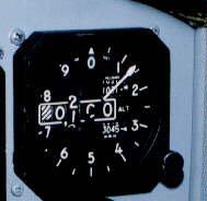
Altimeters inform the pilot the altitude of the aircraft. The information provided by an
altimeter ranges from important for Visual Flight Rules (VFR) flying to critical for an
instrument approach. The altimeter is a device that senses atmospheric pressure. As an
aircraft climbs though the earth’s atmosphere, the pressure decreases. The altimeter
detects this reduction in pressure and displays the reading by mechanical or electronic
means to the pilot.
Prior to takeoff, pilots will set the local altimeter reading (current atmospheric
pressure provided by a weather station on the airfield and is measured by inches of
mercury (Hg)). This will set the altimeter to the Mean Sea Level (MSL) of the airfield
(also referred to as true altitude). After takeoff, if the aircraft is under Instrument
Flight Rules (IFR) or radar control, the pilot will use the altimeter to climb to the
assigned altitude.
Example:
Anchorage Departure Control: "Dice 01, radar contact climb and maintain 12,000
feet."
In this example, the pilot will climb and level the aircraft at 12,000 feet on the
altimeter. The key to this procedure is having the proper altimeter setting. Since the
altimeter senses pressure, it can only provide the correct MSL altitude with the correct
local altimeter setting.
Send all comments to ![]() aeromaster@eng.fiu.edu
aeromaster@eng.fiu.edu
© 1995-98 ALLSTAR Network. All rights reserved worldwide.
| Funded in part by | Used with permission From 90th Fighter Squadron "Dicemen" Aviation |
Updated: February 24, 1999