 |
|||||
| Home | Research | For Teachers | HISTORY Level 1 Level 2 Level 3 |
PRINCIPLES Level 1 Level 2 Level 3 |
CAREER Level 1 Level 2 Level 3 |
| Gallery | Hot Links | What's New! | |||
| Web Administration and Tools | |||||
|
|||||
| Home | Research | For Teachers | HISTORY Level 1 Level 2 Level 3 |
PRINCIPLES Level 1 Level 2 Level 3 |
CAREER Level 1 Level 2 Level 3 |
| Gallery | Hot Links | What's New! | |||
| Web Administration and Tools | |||||
Navigation Systems - Level 3
![]()
A. RADIO THEORY
Some basic radio theory is provided to give a better understanding of the operation of radio navigation system and associated terminology.
l . WAVE CHARACTERISTICS (See Radio Wave figure, on
the right)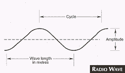
Cycle is the interval between any two points measuring the completion of a single wave movement.
Wavelength is the actual linear measurement, in metres, of one wave.
Amplitude is the strength, or width, of one wave; it decreases with distance from the transmitting site.
Frequency is the number of cycles per second. It is expressed in the following units.
Kilohertz (kHz) - thousands of cycles per second.
Megahertz (MHz) - millions of cycles per second.
Gigahertz (GHz) - billions of cycles per second.
2. RADIO FREQUENCY CATEGORIES:
Table of Radio Frequencies |
|||
| Description | Abbreviation | Frequency | Wavelength |
| Very Low Frequency | VLF | 3 KHz - 30 KHz | 100,000m - 10,000m |
| Low Frequency | LF | 30 KHz - 300 KHz | 10,000m - 1,000 |
| Medium Frequency | MF | 300 KHz - 3 MHz | 1,000m - 100m |
| High Frequency | HF | 3 MHz - 30 MHz | 100m - 10m |
| Very High Frequency | VHF | 30 MHz - 300 MHz | 10m - 1m |
| Ultra High Frequency | UHF | 300 MHz - 3 GHz | 1m - 0.10m |
| Super High Frequency | SHF | 3 GHz - 30 GHz | 0.10m - 0.01m |
| Extremely High Frequency | EHF | 30 GHz - 300 GHz | 0.01m - 0.001m |
3. RADIO WAVES: Radio waves are radiated energy. In free space, they travel in straight lines at the speed of light (approximately 186,000 miles per second). They have the same characteristics as light and heat waves, but are lower in frequency.
They may be subject to the following:
The following terms are used in discussing the transmission of radio waves (See Transmission
of Radio Waves figure, below right).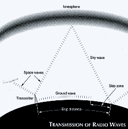
a) Ionosphere. Layers of rarified ionized gas believed to be caused by ultra-violet solar radiation. They range from approximately 60 to 200 miles above the earth and vary according to time of day, season, and latitude;
b) Ground Waves. Part of the transmitted radiation that follows the surface of the earth and is directly affected by the earth and its surface features. Ground waves are not subject to ionospheric or weather changes, but suffers from surface attenuation, which is directly proportional to the frequency. (The lower the frequency, the less the attenuation for a given power);
c) Space Waves. Part of the transmitted radiation that does not follow the curvature of the earth or bend around obstructions but generally travels outwards or upwards from the transmitter;
d) Sky Waves. Part of the transmitted radiation that is reflected or refracted from the ionosphere. A sky wave, when reflected/refracted back by the ionospheric layer, will continue to reflect between earth and sky until completely attenuated;
e) Skip Distance. The distance between the transmitter and the point where the first sky wave returns to earth. It depends upon the height and density of the ionosphere. Great changes in skip distance occur at dawn and dusk as solar radiation varies the position and density of the ionosphere; and
f) Skip Zone. The distance between the end of the useful ground wave and the point where the sky wave is returned to earth.
4. RADIO PROPAGATION: Depending upon the frequency of the radiated signal, radio energy is most efficiently propagated by only one of the three main methods - ground, space or sky waves. The following general rules apply:
5. INTERFERENCE TO AIRCRAFT NAVIGATIONAL
EQUIPMENT: The radiation produced by frequency modulation (FM) and television (TV) broadcast receivers was found to fall within the ILS localizer and VOR frequency band while the radiation produced by the amplitude modulation (AM) Broadcast receivers was found to fall within the broadcast band between 98 kHz and 1600 kHz. This radiation could interfere with the correct operation of ILS, VOR and ADF equipment.
Pilots of aircraft are therefore cautioned against permitting the operation of either portable radio, television or cellular phones on board their aircraft at any time.
The FCC has, after extensive testing, concluded that the switching on or use of hand-held electronic calculators can cause interference to air navigation ADF equipment in the 200-450 kHz frequency range when the calculator is held or positioned within 5 feet of the loop or sense antenna, or lead-in cable installation of the system.
Pilots, especially of small aircraft and helicopters, are therefore cautioned against allowing the operation of calculators on board their aircraft while airborne, and arc to ensure that if carried, the switch of the calculator is in the off position.
Cellular phones have also been shown to interfere with aircraft instruments and should not be allowed. Sky phones which are designed for aircraft use are acceptable.
B. VERY - HIGH - AND ULTRA - HIGH - FREQUENCY RADIO AIDS
1. VOR: The VHF Onmidirectional Range (VOR) operates in the frequency band 108.1 to 117.95 MHz, which is relatively free from static and interference. At minimum instrument altitudes, it gives reliable indications at approximately 50 NM from the station. Normally the VOR may be received 150 NM to 200 NM from the transmitter at high altitudes.
The VOR provides guidance on any track to or from the station. This is why it is called an omni (directional) range.
Most USA and Canadian VOR stations operate continuously, and some have a simultaneous voice feature used for emergency air-ground communications and weather broadcasts. Station identification consists of the three letter station identifier keyed in Morse code at regular intervals. At some locations the VOR voice channel is used to transmit the ATIS broadcast.
The accuracy of track alignment of the omni-range is within a tolerance of +3ş. At certain stations some sectors may contain large errors.
2. TACAN: The Tactical Air Navigation System (TACAN) is an ultra high-frequency (UHF) omni-directional navigational aid that provides slant distance, in nautical miles from a ground station to an aircraft, and the azimuth in degrees from the station. Stations are normally referenced to magnetic north. Equipment consists of a ground station transponder and an airborne receiver/transmitter. The system has a range of up to 200 NM, depending on aircraft altitude.
TACAN stations are owned and operated by the Military. Paired VOR frequencies are published on IFR Charts to allow civil pilots flying DME equipped aircraft to use the DME function of TACAN.
3. VORTAC: This is a combination of a VOR and TACAN at one location. VORTAC provides azimuth navigational information on VHF, and azimuth and distance information on UHF. Separate TACAN airborne equipment is needed to obtain azimuth data from the TACAN part of the system.
4. VHF DIRECTION FINDING: VDF equipment has been established at a number of FSSs and airport control towers. VDF normally operates on pre-selected frequencies in the 115 to 144 MHz range. Information displayed to the controller or FSS position on a numerical readout gives an accurate (+2°) visual indication of the bearing of an aircraft from the VDF site. This is based on the radio transmission received from the aircraft, thus giving the VDF operator a means of providing steering, bearing or homing information to pilots requesting the service.
5. OMNITEST OR VOR EQUIPMENT TEST (VOT): Low-power (2 W) VHF omnitest transmitters are installed at a number of airports to check the accuracy of VOR receivers while aircraft are on the ground. Identification consists of a series of dots.
The VOT radiates a "NORTH" bearing signal on all azimuths that simulates, in the cockpit, a position on the magnetic north (000) radial from the VOR facility. The bearing accuracy of the transmitted signal is maintained within a tolerance of 1°.
C. RADAR SYSTEMS
Primary Surveillance Radar (PSR) detects and reports reflections of aircraft weather, flocks of birds, stationary objects, approximate range of 80 NM.
Secondary Surveillance Radar (SSR) transmits an "interrogation beam" to which an airplane transponder responds, range of 250 NM.
Terminal Surveillance Radar (TSR) systems with both PSR and SSR information, they are capable of digitizing primary radar targets including weather data for presentation.
Independent Secondary Surveillance Radar (ISSR) systems which only provide SSR information.
Radar Digitized Display (RDD-1) is a radar system that uses SSR data remoted from a radar site for display at an area control center. This system does not display weather or non-transponder equipped aircraft.
D. PRECAUTIONARY USE OF NAVIGATION AIDS
Radio beacons sometimes arc subject to disturbances that cause NDB needle deviations, signal fades and interference from distant stations, particularly during night operations. Pilots should be alert for these problems, especially over mountainous terrain.
At times, pilots may observe minor course needle fluctuations and brief flag alarm signals on some VORs. (Some VHF receivers are more susceptible to these irregularities than others). Helicopter rotor speeds and certain propeller RPM settings can cause VOR course fluctuations. Slight changes to the RPM setting will normally smooth out this roughness. Pilots operating over unfamiliar routes should use the TO-FROM indicator to determine positive station passage.
Pilots may encounter random glide path signals when undertaking back course ILS approaches at certain airports. Pilots should ignore all glide path indications when using localizer back courses.
False localizer signals may also occur when outside the localizer area of reliable signal coverage.
When pilots observe apparent abnormal operation of any navigation aid facility, they should report it to the appropriate flight service station, tower, terminal control unit, or ATC center. If it is not practicable to report it at the time, the pilot may report the trouble after landing.
Reports on course shifts are more useful to technical staff if they contain:
Reports concerning the failure of a ground facility to reply should include the date, time, the location of the aircraft, and a brief description of reception and weather conditions at the time.
Send all comments to ![]() aeromaster@eng.fiu.edu
aeromaster@eng.fiu.edu
© 1995-98 ALLSTAR Network. All rights reserved worldwide.
| Funded in part by |
Updated: February 23, 1999