 |
|||||
| Home | Research | For Teachers | HISTORY Level 1 Level 2 Level 3 |
PRINCIPLES Level 1 Level 2 Level 3 |
CAREER Level 1 Level 2 Level 3 |
| Gallery | Hot Links | What's New! | |||
| Web Administration and Tools | |||||
|
|||||
| Home | Research | For Teachers | HISTORY Level 1 Level 2 Level 3 |
PRINCIPLES Level 1 Level 2 Level 3 |
CAREER Level 1 Level 2 Level 3 |
| Gallery | Hot Links | What's New! | |||
| Web Administration and Tools | |||||
![]()

The HSI provides a basic horizontal view of the aircraft's navigation picture. In the
F-15E, it can provide navigation data to selected ground navigation facilities (TACAN or
Instrument Landing System (ILS)) or to onboard navigation systems like the Inertial
Navigation System (INS).
Instrument flying without an HSI requires a fair amount of mental gymnastics; for this
reason, the HSI is becoming more prevalent in general aviation since it provides an
excellent picture for precise navigation.
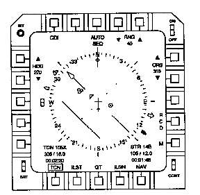
The electronic HSI in the F-15E provides a wealth of information. In the example below,
the HSI provides the crew with the bearing and range to the selected TACAN (a ground based
navigation instrument that transmits a signal 360 degrees from the station) is 305 degrees
and 16.0 miles (the time required to fly to the TACAN is 2 minutes and 20 seconds); the
bearing and distance to the point the INS is steering to is 105 degrees and 12 miles (the
time required to fly to the INS steering point is 1 minute and 48 seconds).
TACAN
INS
data
data
Send all comments to ![]() aeromaster@eng.fiu.edu
aeromaster@eng.fiu.edu
© 1995-98 ALLSTAR Network. All rights reserved worldwide.
| Funded in part by | Used with permission From 90th Fighter Squadron "Dicemen" Aviation |
Updated: February 24, 1999